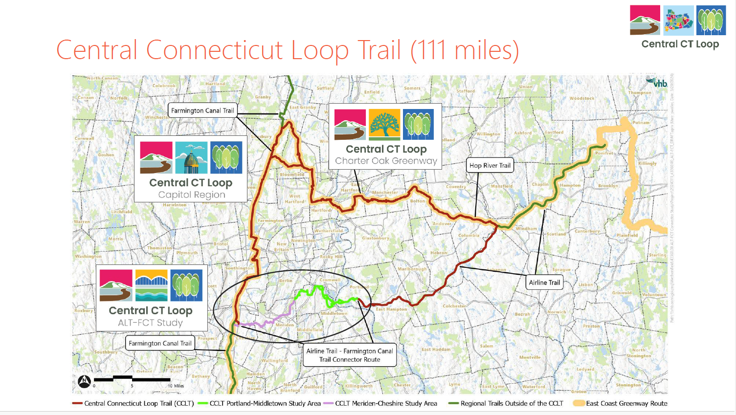
On November 20, 2024, planning/engineering company VHB presented the results of the 2nd study to determine the best route to connect the Air Line Trail in Portland with the Farmington Canal Heritage Trail in Cheshire. (A previous study of the Meriden section was conducted several years ago.) Completion of this 23-mile connector trail shown in the purple and green sections in the area circled below will be a boon to recreational and commuting bicyclists and to walkers in our area. It will also go a long way to completing a 111-mile loop trail: the Central Connecticut Loop Trail (CCLT).
The entire slideshow presented on November 20, 2024 can be viewed here.
We offer our readers here the results of the study of the Middletown and Portland sections, shown in lime green within the oval above. To enlarge these images, right click on the image and then click on “open image in a new tab.” This summary starts at the west end (i.e. the Meriden-Middletown boundary) and works east.
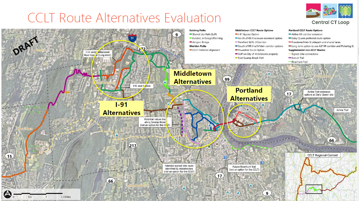
The map above is an overview of the Middletown-Portland study area. Circled in yellow are 3 areas where more in-depth study and route evaluation were required.
On the left (west) side, the orange line shows the route from downtown Meriden, which passes through Meriden’s Giufridda Park west of Bradley Hubbard Reservoir and then descends northeast along the eastern slope of Mt. Lamentation. At the Meriden-Middletown boundary (shown by the dotted line) the line turns purple. The zig-zagging occurs in areas where the grade is steep, requiring trail switchbacks. Switchbacks stretch out the distance travelled to manage more easily a steep elevation change. The purple section is located on City of Middletown-owned open space. It crosses Atkins Street and connects to the north side of Timber Ridge Road just west of Middle Street.
Now we turn to the area labelled I-91 Alternatives in the map above. How will the trail get under Interstate 91 and connect with the existing Mattabesset Bike Path? The image below shows a close-up of the 3 options.
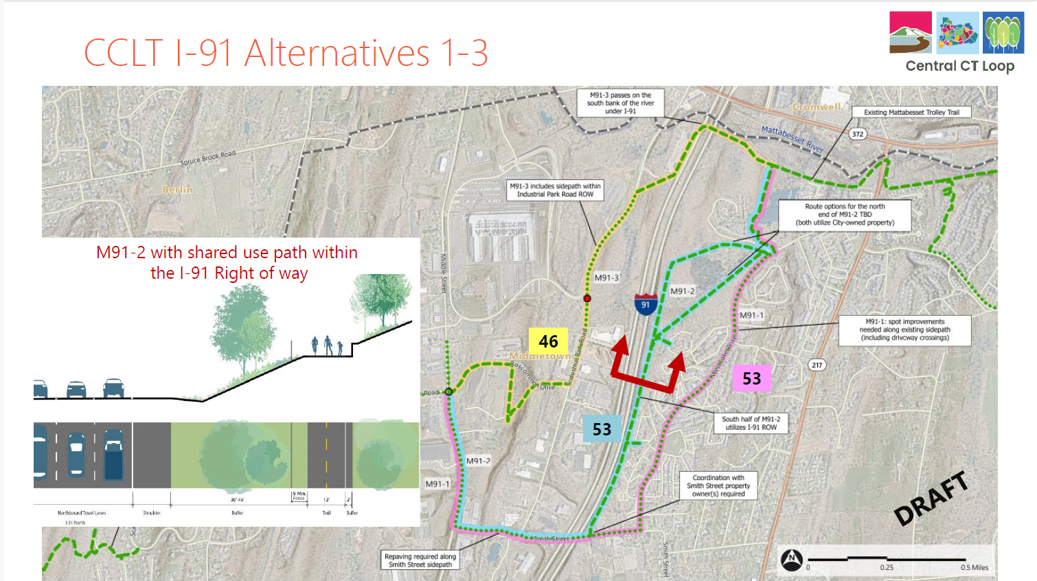
The segment in pink (M91-1) is the existing Westlake Bike Path along Westlake Drive. This route alternative is not ideal for the CCLT since it is narrow, heavily used, includes a steep hill, and has many driveway crossings, but it has a significant advantage, at least temporarily: it has already been built. The plan is to improve it.
The route alternative in light blue with a green dashed line (M91-2) lies mainly within the I-91 right-of-way. It is flatter, separated from a roadway, and would have fewer pedestrians. It could be built in the future. Note that both of these alternatives received the same score (shown in the colored boxes) of 53. The inset on the left shows a cross-section of this alternative beside I-91where the red frame is located on the map.
The alternative in yellow goes under I-91 farther north beside the Mattabesset River and follows Industrial Park Road. Besides the lower score of 46, this option has other drawbacks and uncertainties, so it is not the preferred route.
Going east from the sections described above, the preferred route follows the existing Mattabesset Bike Path along the Mattabesset River to Tuttle Road. The City of Middletown is already planning to extend this path from Tuttle Road south, past Lawrence School, across Mile Lane, and to Middletown High School. This extension has been referred to in the past as the northern part of the Newfield Corridor Trail.
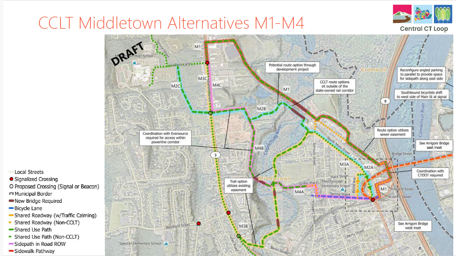
The next challenge is to get from Middletown High School to the Arrigoni Bridge and Portland. This section was the most difficult to plan and it will be the most expensive segment in Middletown to construct.
The preferred route alignment is as follows. From Middletown High School to Newfield Street via LaRosa Lane (the main driveway to the high school); south along the west side of Newfield Street on a separated multi-use trail; across Newfield Street where the power lines cross, where a flashing beacon pedestrian signal could be installed; east along the boundary of the new apartment complex, farther east through the development site1 to the railroad corridor; southeast parallel to but outside the railroad corridor on a board walk to a bridge across the Coginchaug River and onto North Main Street at Johnson.
1 – The Newfield Street developer has been supportive of the CCLT running through the site.

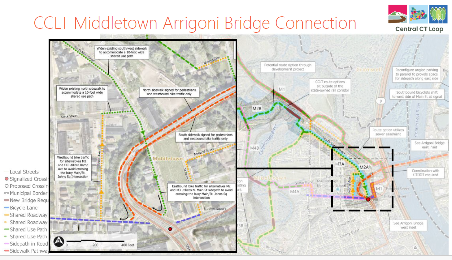
To reach the bridge from Johnson Street, cyclists would use a separated multi-use path along the southwest side of North Main Street to reach the south sidewalk of the Arrigoni Bridge. Westbound cyclists coming to Middletown from Portland would use the bridge’s north sidewalk and exit onto Spring Street, turn right on Rome Ave, right on Stack, and left onto the multi-use path along North Main westbound.
Now we turn to Portland.
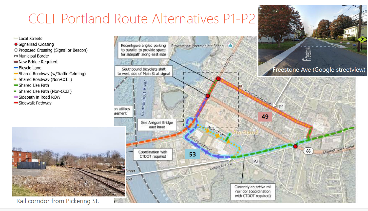
In Portland, there are 2 possible ways cyclists could reach the original rail bed of the Air Line Trail (shown above in green) near the intersection of Air Line Avenue and Route 66. (See the red dot on Route 66.)
The most direct route is shown above in the blue and green lines along Pickering Street and the still active Air Line Trail spur. If and when this spur becomes inactive due to deterioration of the railroad bridge across the river, the CCLT could be constructed in the rail right-of-way. The other option would be for cyclists to continue straight from the bridge and follow Main Street on a multi-use path going northbound (striped bike lanes for those riding southbound) to Freestone Avenue, go east on Freestone across High Street, and connect with the original Air Line Trail.
This study assumes that the original railbed of the Air Line Trail between Route 66 and Route 17 can be used for the CCLT. We certainly hope that is the case, but not all property owners have been consulted on that question.
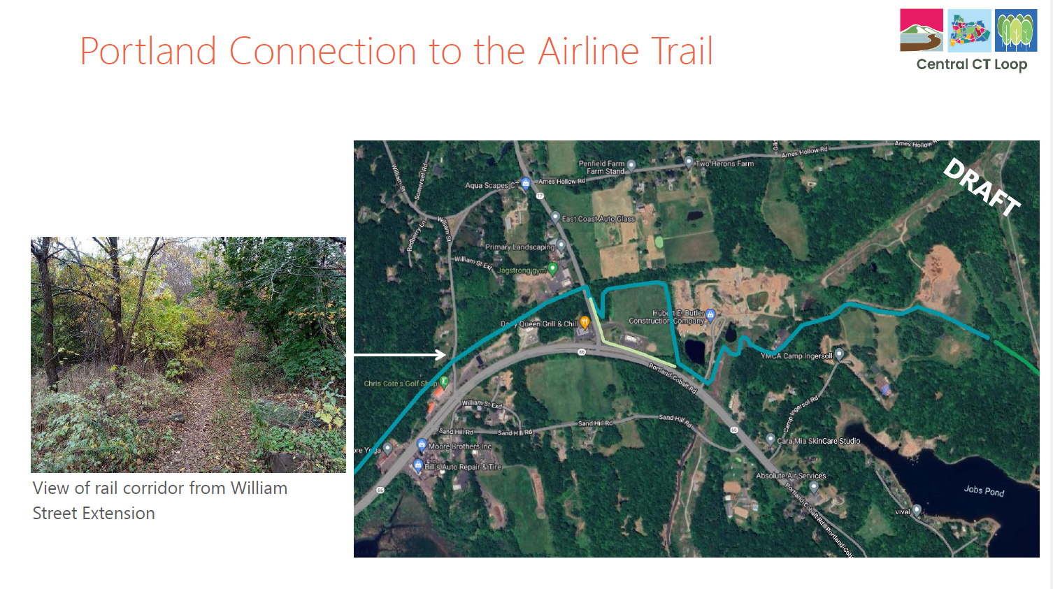
The route segment between Route 17 and the existing western terminus of the bikeable Air Line Trail (behind the Northern Middlesex YMCA Camp Ingersoll) is currently in discussion between Portland’s Air Line Trail Committee and several property owners. Settling on a route across the properties of 3 businesses (Dairy Queen, Butler Construction, and Eversource) has been difficult but this is an ongoing priority.
Thank you for your interest in this exciting project. Again, you can open and download the entire study slide deck here.


