




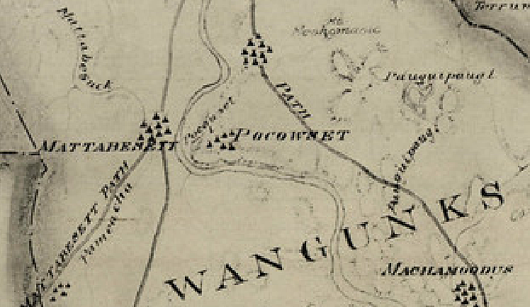
A section of “Map of The State of Connecticut Showing Indian Trails, Villages, and Sachemdoms Made For the Connecticut Society of the Colonial Dames of America” by Mathias Spiess and Hayden Griswold, 1930.
This map shows approximate locations of Wangunk camps on both sides of the Connecticut River before the settlement of Europeans in what became Middletown and Portland. (The entire statewide map may be found here.)
As we enjoy scenic views from the Midden Lookout Park over the 1000-acre Floating Meadows, we are reminded of the Wangunk people who lived, hunted, and fished on these rivers, coves, and shorelines for thousands of years before European settlers arrived.
At the 250th anniversary of the English settlement of Middletown, the city published a book, “1650-1900. Mattabeseck” about the colonial and post-colonial history of Middletown based on earlier sources. One revealing quote from that book is on page 99:
Before the settlement of the English, the Indians had a burial ground at Newfield, with rude monuments placed over their dead, on which emblematic devices were carved. Some of these stones were in a stone wall fencing the property a number of years ago. At the foot of the bank, called “the Point,” where the Sebethe [former name of the Mattabesset River] forms a cove, the Indians had a “Medicine House,” where the sick were taken and given a sweat by standing or lying over hot stones buried in the earth. Then they rushed out and plunged into the waters of the cove. This cove is now nearly filled with reeds, and only in high water can a boat reach the point.
We believe that this “point” was somewhere east or northeast of the current properties of Springside Apartments or Middletown Toyota. Viewed from the water, this “point” was probably to the west of the Coginchaug River near the confluence with the Mattabesset, or, paddling a short distance upstream from the confluence on the Mattabesset, on the left or west side of the river.